Last week, the audience was disturbed by the news that the Crimean Peninsula is moving towards Russia, not only thanks to the political will of the population, but according to the laws of nature. What is lithospheric plates and some of them are geographically Russia? That makes them move and where? What territory do you want another “join” to Russia, and which threaten to “run away” in the US?
“As we go”
Yes, we all go somewhere. As you read these lines, you move slowly: if you are in Eurasia, to the East at a speed of about 2-3 cm per year, while in North America, with the same speed to the West, but if somewhere at the bottom of the Pacific ocean (what were you doing there?), it takes on Northwest at 10 centimeters per year.
If you lean back in the chair and wait for approximately 250 million years, it will be on the new supercontinent that will unite all of the earth’s land, on the mainland Pangea Ultima, named in memory of the ancient supercontinent Pangaea that existed just 250 million years ago.
Therefore, the news that “Crimea is moving” is hardly news. First, because the Crimea with Russia, Ukraine, Siberia and the European Union is part of the Eurasian lithospheric plate and they all move together in one direction the last hundred million years. However, Crimea is still part of the so-called Mediterranean mobile belt, it is located on the Scythian plate, and most of the European part of Russia (including St. Petersburg) — on the East European platform.
And here is where confusion often occurs. The fact that in addition to huge sections of the lithosphere, such as the Eurasian or North American plate, there are completely different tiles smaller. If it is arbitrary, then the earth’s crust is composed of continental lithospheric plates. They consist of ancient and very stable platforms and areas of mountain building (ancient and modern). And already the platforms themselves are divided into plate – smaller areas of cortex, consisting of two “layers” — of the basement and cover, and shields, “single-layer” outcrops.
Case nelikovanyh these plates consists of sedimentary rocks (e.g. limestone, composed of a plurality of shells of marine animals that lived in the prehistoric ocean above the surface of the Crimea) or magmatic (ejected from volcanoes and the frozen mass of lava). And the Foundation slabs and boards often consist of very old rocks, mainly metamorphic origin. The so-called igneous and sedimentary rocks, to plunge into the depths of the earth’s crust, where high temperatures and enormous pressure with them are a variety of changes.

In other words, a large part of Russia (except Chukotka, and Transbaikalia) is located on the Eurasian lithospheric plate. However, its territory is “divided” between the West Siberian plate, Aldan shield, Siberian and East-European platform and the Scythian plate.
Probably about the movement of the last two slabs and said the Director of the Institute of applied astronomy (IAA), doctor of physical and mathematical Sciences Alexander Ipatov in his oral message. And later, in an interview with Indicator, he said: “We do observations, which allow us to determine the direction of the movement of crustal plates. Plate on which the station is located, moves with a speed of 29 millimeters per year in the North-East, where Russia. And the stove, where Peter moves, you might say, to Iran, to the South-South-West”. However, it is not so much a discovery, because scientists know about the movement for several decades, and it began in the Cenozoic era.
This was confirmed by the publication of a “Federal news Agency” and geologist Yuri Dolotov: “Crimean mountains are a continuation of the Caucasus mountains, but do not constitute a uniform structure, but divided the so-called Scythian plate — deflection foothill Crimean-Caucasian folded system, which also separates the Crimea from the Eastern European platform, that is from the Peninsula a few hundred kilometers.”
“Moving in movable”
For the first time shifted the continents German meteorologist, geophysicist and polar Explorer Alfred Wegener. He explored the coast of the two continents on the sides of the Atlantic, remains of fossil organisms, their geological features and in 1912 he proposed the hypothesis of continental drift, stating that the continents can move, and once South America and Africa were a single entity (although it is very often mentioned that even Francis bacon noticed that South America and Africa fit together like tiles in a mosaic, it is, apparently, wrong).
The theory of Wegener was accepted with skepticism, mostly because he could not offer a satisfactory mechanism that explains the movement of continents. He believed that the continents are moving, breaking the earth’s crust, like icebreakers ice, due to the centrifugal force from Earth’s rotation and tidal forces. His opponents said that the continents-the”icebreakers” in the process of the movement would change its appearance beyond recognition, and centrifugal and tidal forces are too weak to serve for them “engine”. One critic calculated that if tidal effects so strong, so quickly moving the continents (Wegener evaluated their speed of 250 inches per year), it would stop the rotation of the Earth in less than a year.
By the end of 1930-ies the theory of continent drift was rejected as unscientific, but by the mid-twentieth century to it had to go: open mid-ocean ridges and found that in the area of these ridges continuously formed new crust, thus “separating” the continents. Geophysicists investigated the magnetization of the rocks along mid-ocean ridges and found the “strip” with multidirectional magnetization.
It turned out that new oceanic crust “records” as the Earth’s magnetic field at the time of formation, and scientists got a great “ruler” for measuring the speed of the conveyor. So, in 1960-e years the theory of continental drift came back a second time, already definitively. And this time scientists have been able to understand what moves the continents.
“Ice” boiling the ocean
“Imagine the ocean, where floating ice, it has water, there is ice and, say, some ice still frozen wooden rafts. Ice is lithospheric plates, rafts — the continents as they float in the substance of the mantle,” — explains the corresponding member of RAS Valery Trubitsyn, chief researcher of the Institute of physics of the Earth named after O. Yu. Schmidt.
He’s still in 1960-e years have put forward the theory of the structure of the giant planets, and in the end of XX century began to create a mathematically grounded theory of the tectonics of the continents.
The intermediate layer between the lithosphere and the hot iron core in the center of the Earth — mantle is composed of silicate rocks. Temperature changes from 500 degrees Celsius at the top to 4000 degrees Celsius at the core. Therefore, a depth of 100 kilometers, where the temperature is over 1300 degrees, the substance of the mantle behaves as a very dense resin and flows at a rate of 5-10 centimeters per year, says Trubitsyn.
As a result, in the mantle, as in a pot of boiling water, convection cells occur in the area where one side of the hot substance ascends, the other is cooled down.
“In the mantle there is about eight of these big cells, and many more small,” the scientist said. Mid-ocean ridges (e.g. mid-Atlantic) — this is the place where mantle material rises to the surface and where new crust is born. In addition, there are areas of subduction where the plate begins to “creep” under the next and down into the mantle. A subduction zone is, for example, the West coast of South America. Here are the most powerful earthquakes.
“So plates take part in the convective circulation of mantle material, which while on the surface becomes temporarily solid. Plunging into the mantle, the substance of the plate is heated and softened again,” explains geophysicist.

In addition, from the mantle rise to the surface of individual jets of substance — plumes, and these jets have a chance to destroy humanity. Because mantle plumes are the cause of SUPERVOLCANO (Yellowstone, see the nightmare: destroy SUPERVOLCANO the US? And pity is Russia?) These points are in no way related to the lithospheric plates and can stay in place even when moving the plates. When the plume is caused by a giant volcano. Volcanoes a lot, they are in Hawaii, in Iceland, a similar example is the Yellowstone Caldera. Supervolcanoes can produce eruptions thousands of times more powerful, than most conventional-type volcanoes of Vesuvius or Etna.
“250 million years ago a volcano on the territory of modern Siberia killed almost everything alive, survived only ancestors of dinosaurs,” — said Trubitsyn.
Agreed — sold
Lithospheric plates are composed of relatively heavy and thin basaltic oceanic crust and lighter, but much more “thick” of the continents. Plate with the continent and “frozen” around him oceanic crust may go forward, while the heavy oceanic crust sinks beneath a neighbor. But when facing the continent, they can not take to each other.
For example, approximately 60 million years ago the Indian plate broke away from what then became of Africa and went North, and about 45 million years ago was found with the Eurasian plate, in the place of the collision increased the Himalayas — the highest mountains on Earth.
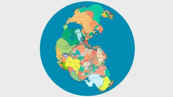
The movement of plates, sooner or later will bring all the continents to one, as converge to one island leaves in an eddy. In the history of Earth’s continents approximately four to six times joined and dissolved. The last supercontinent Pangea existed 250 million years ago, before it was the supercontinent Rodinia, and 900 million years ago, before it even two. “And already, it seems, will soon begin the unification of the new continent,” — says the scientist.
He explains that the continents act like a heat insulator, and the mantle beneath them begins to heat up, there are updrafts and therefore the supercontinents after some time apart.
America will carry away Chukotka
Large plates painted in the textbooks, they may call any: Antarctic plate, Eurasian, North American, South American, Indian, Australian, Pacific. But on the borders between the plates there is a real chaos of the many microplot.
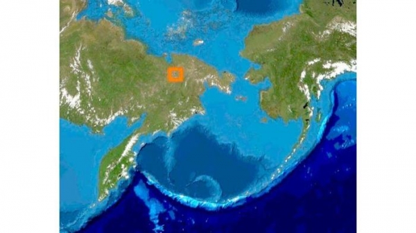
For example, the boundary between the North American plate and the Eurasian is not on the Bering Strait, and far to the West, on the ridge Chersky. Chukotka, therefore, is part of the North American plate. The Kamchatka Peninsula partly located in the zone of the Okhotsk microplate and partly in the area of the Bering sea microplate. And Primorye, Amur is located on the hypothetical plate, the Western edge of which rests on the lake.
Now the Eastern edge of the Eurasian plate and the Western edge of the North American “cool”, like gears: America rotates counterclockwise and Eurasia clockwise. As a result, the Chukotka may finally take off “in the seam”, and in this case, the Land may receive a giant circular suture that will pass through the Atlantic, Indian, Pacific and Arctic ocean (where it is still closed). And the Chukotka would continue “in orbit” in North America.
The speedometer to the lithosphere
The theory of Wegener revived, not least because scientists have the ability to accurately measure the displacement of continents. Now, this is done using a satellite navigation system, but there are other methods. All they need to build a common international reference system International Terrestrial Reference Frame(ITRF).
One of these methods — radiointerferometry with very long base (VLBI). Its essence lies in the simultaneous observations of distant quasars using several radio telescopes in different parts of the Earth. The time difference of the signals allows high accuracy to determine the offset. Two other ways to measure the speed of laser ranging observations using satellites, and Doppler measurements. All these observations, including using GPS, conducted on hundreds of stations, all these data are brought together, and in the end we get a picture of the continental drift.
For example, the Crimean Simeiz, where the laser sounding station and a satellite station positioning “goes” in the North-East (azimuth of about 65 degrees) at a rate of approximately 26.8 millimeters per year. Zvenigorod near Moscow moves about a millimeter per year faster (27.8 mm per year) and the course keeps to the East of about 77 degrees. And, say, the Hawaiian volcano of Mauna Loa is moving to the Northwest at twice — 72,3 mm per year.
Lithospheric plate can also deform, and parts can “live your life”, especially at the borders. Although the extent of their independence is much more modest. For example, Crimea itself is moving to the North-East at a speed of 0.9 millimeters per year (and rising by 1.8 mm) and Zvenigorod at the same rate moving somewhere in the South-East (and down — by 0.2 millimeters per year).
Trubitsyn said that this independence is partly due to “a personal story” different parts of the world: main parts of continents, platforms, can be fragments of ancient lithospheric plates that are “fused” with their neighbors. For example, the Ural mountains — one of the seams. The platform is relatively rigid, but the part around them can deform and go at will.