 They have created a brand new concept.
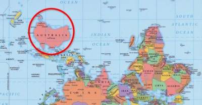
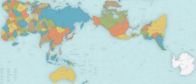
Many are aware that the usual map of the world not too accurately reflects the actual ratio of the areas of the countries, and especially the seas and oceans. The use Mercator projection leads to many distortions when, for example , Greenland looks larger than Australia… a Fundamentally new projection, was proposed by Japanese designers, has allowed us to build the most accurate world map ever seen of humanity.
How do they do it?

The traditional world map is built the old-fashioned way, where the image from the surface of the globe is transferred onto a flat map using a Mercator projection. As a result, we get the map Greenland is several times larger than Australia, while in fact Greenland is three times less…

And here is a map that is built according to AuthaGraph projection, may be called really innovative! Here the proportions of land and water remain unchanged and correspond to what we see on the globe. For this development, the company AuthaGraph has received a prestigious award Japanese Good Design Award.

The author of the revolutionary new projection – Hajime of Narukawa. The essence of his idea is that the spherical surface of the globe is divided into 96 triangles.

Then there is the original process of transfer of image on a plane by combining different ways of projecting through the intermediate objects. Such “multiple” reduces the number of errors and monstrous distortions that arise in the traditional unfolding of the surface of the globe into a flat map.
 [/center
Of course, perfection is impossible to achieve, but the map from AuthaGraph maximum approached him.

As explained by the authors of the new map of the world the necessity of its appearance?
“Antarctica was discovered in 1820, and the first man reached the North pole in 1909. In the twentieth century to the forefront of world politics, relations between East and West and problems of North – South. The main territorial interest was land that was the habitat of man. But since the end of the twentieth century dwindling resources and environmental problems has forced to pay attention to the polar regions and the area of the oceans…
World map AuthaGraphic is committed to supporting this new point of view and show how it really looks like our earth and are distributed on the interests of different countries and groups.”


According to its creators, new world map will look at the planet and separate her from a new angle and get rid of the ingrained stereotypes like the “Western world”, “far East”, “go North”.
For comparison, the world map, drawn in 1844

World map 1490-ies, with which Columbus had to convince Ferdinand of Aragon and Isabella of Castile in need of support expedition